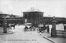
Conçue par Moncet et Revéront, inspirée par celle de Deauville-Trouville,
la gare de Dalat a été construite en 1938 dans un endroit excentré.
Được thiết kế bởi Moncet và Revéront, lấy cảm hứng từ Deauville-Trouville,
Nhà ga Đà Lạt được xây dựng vào năm 1938 ở một vị trí hẻo lánh.
(Le Nouvelliste d’Indochine, 27 novembre 1938)
Không gian nội thất được chiếu sáng lung linh bởi các ô cửa kính nhiều màu ở phần chân mái. Đây chính là phòng chờ cho hành khách, một không gian rộng lớn với các góc cạnh và đường nét ngay hàng thẳng lối, vừa uy nghi cao cả nhưng cũng thật giản dị.
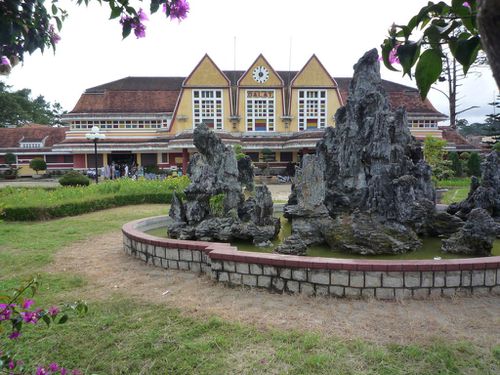
Do cuộc chiến tranh Việt Nam, tuyến đường sắt Tháp Chàm–Đà Lạt ngừng hoạt động vào năm 1972. Tuy vậy, từ năm 1991, nhà ga cùng với đoạn đường sắt Đà Lạt–Trại Mát được khôi phục để phục vụ hoạt động du lịch. Ga Đà Lạt được xem như một trong những công trình kiến trúc nổi tiếng nhất của thành phố, và cũng nằm trong số những nhà ga đẹp nhất Việt Nam.
1968
Gare de Trouville - Deauville
C'est une gare de la Société nationale des chemins de fer français (SNCF), desservie par des trains Intercités et TER Basse-Normandie.
Sommaire
Situation ferroviaire
Établie à 6 m d'altitude, la gare de Trouville - Deauville est située au point kilométrique (PK) 219,243 de la ligne de Lisieux à Trouville - Deauville dont elle est le terminus après la gare de Pont-l'Évêque. Elle est également le terminus de la ligne de Mézidon à Trouville - Deauville (partiellement déclassée) après la gare de Blonville-sur-Mer - Benerville.Histoire
Afin de développer la nouvelle station balnéaire de Deauville, le duc de Morny obtint en 1860 le prolongement de la ligne Paris-Saint-Lazare - Lisieux - Pont-l'Évêque. La première gare fut inaugurée le 1er juillet 18631.En 1913, on dresse un avant-projet visant à reconstruire la gare dans le style régional normand. Mais la Première Guerre mondiale empêche la réalisation du projet. En 1929, un quai de débarquement est établi pour le transport des chevaux de course2.
Les plans sont validés en janvier 1930 et les travaux débutent en novembre de la même année. Le bâtiment voyageurs d'origine est détruit et les nouveaux bâtiments conçus par Jean Philippot3, auteur de la gare de Vanves - Malakoff4, sont bâtis en retrait par rapport à la grande route afin de dégager une place aménagée par permettant aux voitures de stationner et de manœuvrer5. La nouvelle gare est inaugurée, le 26 juillet 1931, par Raoul Dautry alors directeur général de l'Administration des chemins de fer de l'État.
En 1932, l'architecte Léopold Mias aménage la place Louis-Armand4.
Architecture
Adoptant un plan en U, le bâtiment principal, avec hall et locaux administratifs, et deux annexes pour les services de messagerie et bureaux de la compagnie de chemin de fer, s'ordonnent autour d'une cour des voyageurs. Les bâtiments sont en béton, avec un parement de briques dans les parties basses et de ciment peint imitant un pan de bois. Le toit à forte pente est porté par des fermes cintrées en béton armé4.Dans le hall des voyageurs, au volume demi-cylindrique, deux peintures marouflées de Louis Houpin datée de 1932 représentant un plan de Trouville et Deauville et d'une carte de Normandie4.
Trois quais de 300 mètres, pavés de grès jaune et rouge de Beugin et dotés d'abris pour les voyageurs en béton couverts de tuiles plates, desservent six voies principales, complétées par cinq voies annexes dédiées au nettoyages des rames4.
Elle est parfois comparée à la gare de Pointe-Noire en République du Congo. Cette ressemblance à pour origine le fait qu'elles ont été réalisées, dans un style néo-normand, la même année par le même architecte6.
La gare fait l’objet d’une inscription au titre des monuments historiques depuis le 5 juillet 20107. Les éléments concernés par la protection sont8 : les façades et toitures de l'ensemble du bâtiment ; le grand hall des voyageurs ; les quais avec les abris, les lampadaires et luminaires.
Service voyageurs
Accueil
Gare9 SNCF, elle dispose d'un bâtiment voyageur, avec guichet, ouvert tous les jours et des automates pour l'achat de titres de transport. Différents services sont proposés, notamment : un accueil des personnes handicapées, une borne Wi-Fi, un relais toilette coin nurserie, des cabines téléphoniques, une cabine pour photos d'identité. Une boutique de presse et tabac est installée dans le hall.Desserte
Trouville - Deauville est desservie9 par des trains Intercités qui effectuent des missions entre Paris-Saint-Lazare et Deauville, et par des trains TER Basse-Normandie qui circulent entre Deauville et les gares de Lisieux ou Dives - Cabourg.Intermodalité
Un parc pour les vélos et un parking pour les véhicules sont aménagés9. Un arrêt est desservi par des cars interurbains de la ligne 20 du réseau des Bus Verts. Une station de taxis est installée devant la gare et un loueur de véhicule est installé dans le hall.Notes et références
- Didier Hébert, « Deauville : création et développement urbain » dans In Situ, n°6, septembre 2005
- Département du Calvados - Conseil général - Délibérations - Deuxième session de 1930, Caen, A. Olivier, 1930, p. 40 [lire en ligne [archive]]
- Maryse Angelier, « Chronique du bord de mer » dans la Vie du Rail, n°1795, 28/05/1981
- Alain Nafilyan, Éric Diouris et Frédéric Henriot, Monuments historiques du XXe siècle en Basse-Normandie, In-Quarto, 2010
- La construction moderne, 27 décembre 1931, 47e année, n°13
- Diala Touré, Créations architecturales et artistiques en Afrique sub-saharienne (1948-1995) : Bureaux d'Études Henri Chomette, L'Harmattan, 2002 (ISBN 9782747531566), p. 43 extrait [archive] (consulté le 30 juin 2011)
- « Notice no PA14000090 » [archive], base Mérimée, ministère français de la Culture
- Service territorial de l'architecture et du patrimoine du Calvados [archive] (liste mise à jour le 31 décembre 2010)
- Site SNCF Ter Basse-Normandie, Informations pratiques sur les gares et arrêts : Gare de Trouville - Deauville lire [archive] (consulté le 30 juin 2011).
| Trouville - Deauville | ||
 Le bâtiment voyageurs vue du côté ville. |
||
| Localisation | ||
|---|---|---|
| Pays | France | |
| Ville | Deauville | |
| Adresse | Place Louis-Armand 14800 Deauville |
|
| Coordonnées géographiques | 49° 21′ 35″ Nord 0° 05′ 04″ Est | |
| Gestion et exploitation | ||
| Propriétaire | RFF / SNCF | |
| Exploitant | SNCF | |
| Services | Intercités Normandie TER Basse-Normandie |
|
| Caractéristiques | ||
| Ligne(s) | Lisieux - Trouville-Deauville Dives-Cabourg - Trouville-Deauville |
|
| Voies | 5 | |
| Quais | 3 | |
| Altitude | 6 m | |
| Historique | ||
| Mise en service | 1er juillet 1863 | |
| Ouverture | 26 juillet 1931 (bâtiment de J. Philippot) | |
| Architecte | Jean Philippot | |
| Classement | ||
| Correspondances | ||
| Cars | voir Intermodalité | |
| modifier | ||
http://fr.wikipedia.org/wiki/Gare_de_Trouville-Deauville
L'architecture néo-normande
L'architecture néo-normande est un style de villas créé selon Claude Mignot par Jacques Baumier à Houlgate dans la seconde moitié du XIXe siècle1. Forme normande du régionalisme, elle se caractérise par des bâtiments construits à partir d'une structure à pan de bois traditionnelle, mais avec des matériaux modernes. Exemple :Gare de Deauville: Pointe-Noire? Non, Dalat !
http://voyage-congo.over-blog.com/article-gare-pointe-noire-deauville-non-dalat-73774121.html
En effet, au ViêtNam (ex colonie française de l'Indochine), on trouve la gare de Dalat (ou Da-Lat) dessinée en 1932 et dont la façade est marquée par trois pignons, dont celui du milieu porte une horloge. Comme à Deauville !
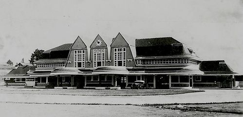
Cet édifice est dû aux architectes français Paul Moncet et Reveron. Ils ont été visiblement influencés par leur collègue Phillipot.
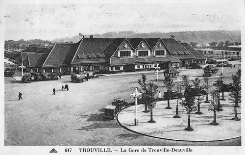
Bien entendu, ce n'est pas non plus une réplique. L'architecture de la gare de Dalat est marquée par les caractéristiques locales. La forme des pignons et les toits diffèrent. Le style Art Déco est lui toujours présent.
La ligne du chemin de fer indochinois a demandé 30 ans d'efforts. Il a fallu affronter les montagnes et percer des tunnels.
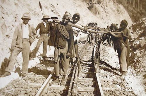
La Société de Construction des Batignolles a oeuvré en Indochine. Cela me rappelle un certain CFCO... les scènes de chantier sont étrangement ressemblantes.
Sources : http://www.vnafmamn.com/tracing_shangrila.html
http://vn.360plus.yahoo.com/trchoa08-kts/article?mid=56
MISSION FOR LANG BIAN COG RAILWAY  STUDIED MAP FOR COG RAILWAY  DALAT – THAP CHAM RAILROAD  EO GIO'S TOPOGRAPHIC MAP  DON DUONG'S TOPOGRAPHIC MAP  DALAT-TOURCHAM RAILWAY's MAP (LARGE SIZE: 3.7 MB)  ARMORED CAR EQUIPPED WITH CANNON  SELF-PROPELLED ARMORED CAR  BRIDGE NEAR TOURCHAM 
PASSENGER CARS  KRONG PHA STATION (1947)  TOUR CHAM STATION (1947)  ANCIENT CHAM TOWERS  TOUR CHAM RAIL YARD (1943)  "CHEMIN DE FER" INAUGURATED (1936)  VHX 31-201 COGWHEEL LOCOMOTIVE  LOCOMOTIVE AT DALA DEPOT  DI AN TRAIN STATION 
CHIEF OF TRAIN STATION & HIS CREWS  |
A BRIEF HISTORY OF DALAT RAILWAY Most people know that Dalat has the most beautiful train station in the Southeast Asia (with the trait of Art-Deco style in architectural structure), but not many realize that it once had one of a few unique cog railways in the world. You might wonder what the heck is cog railroad. It's a sawlike track system, or a railroad with a toothed/serrated central rail between the bearing rails that engages with a cogwheel under the locomotive, providing traction for ascending very steep slopes and keep the train from sliding too fast when descending down hill. But let's make a quick check out on how the French has built that railroad section in the early 20th century. In 1903, the French built a railway that connected the cool, high city of Da Lat with the hot, low-lying coastal area of Phan Rang so French people could more conveniently live and work for periods of time in the cool city of Da Lat. The 84km long Da Lat-Thap Cham route include a 41km long Thap Cham-Krong Pha section opened in 1919 and a 43km long Krong Pha-Da Lat section opened in 1932, the latter of which is sloping and has cog rails in three different places and five tunnels. The chronology of building that rail route can be listed as follow (see map on the left column for better understanding of Thap Cham-Dalat route): CHRONOLOGY (Lang Bian train-route construction) Beginning 1903 through 1913: from THAP CHAM (Tourcham) to TAN MY, 41 Km completed and used in 1913 1919 completed from TAN MY to SONG PHA (Krongpha) 1928 " from SONG PHA to EO GIO (Bellevue) 1929 " from EO GIO to DON DUONG (Dran) 1930 " from DON DUONG to TRAM HANH (Arbre Broye) 1932 " from TRAM HANH to DALAT A total length of 84 Km from Thap Cham (Tourcham) to Dalat In 1932, two French architects, Moncet and Reveron, designed the Da Lat railway station and hired Vietnamese companies to build this station about two kilometers from Xuan Huong Lake in Da Lat. The station's design was distinctly western but also has some characteristics of a Cao Nguyen (Central Highland) communal house with its high, steep roof. The station is divided into three areas, each of a nice size with stained-glass windows and arched ceilings. After the Lang Bian cog railway was open, as the whole network of railways in French colonial Indochina was built by France and used to be referred as CFI (Chemins de Fer de l'Indochine, for convenience let's use CFI as a French official entity in this article) Cogwheel locomotives were imported into Vietnam at two phrases: The first phrase, CFI bought a total of 7 locomotives type HG 4/4, – 5 locomotives (1924) made by Swiss Company SLM Winterthurand (Schweizerische Lokomotiv- und Maschinenfabrik) and 2 HG 4/4 locomotives # 40-306 and 307 (built and paid by Germany after they had been damaged during World War I) – When operating between 1924 - 1929, those locomotives bore serial number in sequence from CFI 40-301 to CFI 40-307. On second phrase, between 1930-1947 CFI acquired 6 locomotives with 2 HG 4/4 locomotives (serial number CFI 40-308 and 40-309 from SLM in 1930) and 4 locomotives (serial number in sequence of CFI 31-201 through 31-204) type 3/4 in 1947 from Furka-Oberalp Bahn, Switzerland, which had completely electrified its railway in 1941 . During the time of Japanese occupation in Indochina, CFI lost 3 locomotives type HG 4/4 without tracing records, the rest later was transferred to Vietnam Hoa Xa (VHX after the French had pulled out of Vietnam). The serial numbers of all locomotives remained the same, but different letter code of VHX, instead of CFI. In classic technology, the steam engines were fueled by coal, creating steam that was converted into a pulling power of 600 CV - 820 CV (Chevaux-Vapeur). Due to Viet Cong's constant sabotage and mining, the trains hauled their last passengers until 1968 and ceased the operations of Lang-Bian route afterwards. It took the French 30 years with great effort to built such an extraordinary cog railway in Indochina period, let's see how Hanoi propagandists distorted the history of Lang-Bian railway and blamed someone else for the destruction of that historic cog railway in only one year (1976): "Da Lat was built in 1907. The Krongpha train station and a nearby black iron bridge are vestiges of the French presence in Vietnam. The French intended to build a railway from Da Lat to the coastal city of Phan Rang. The train would have climbed through the most beautiful mountain passes in Vietnam, the Dran Pass and the Krongpha Pass, also known to the French as Bellevue Pass. The Krongpha railway, one of only two cog railways in the world, was unfinished after the French withdrawal. Many traces of it, however, can be still be found close to the road...." (Source: ThanhNien Online - March 31, 2008) Click here for the original screen shot of the article And how they blamed the destruction of Dalat cog railway on "American Imperialists" during the war: ...As soon as the station went into use in 1936, trains with brand new Japanese locomotives carried passengers and freight along three routes: Thap Cham-Da Lat, Nha Trang-Thap Cham-Da Lat, and Saigon (now Ho Chi Minh City)-Thap Cham-Da Lat. The station had three Japanese made steam locomotives. The steam engines were fueled by wood, bringing the temperature up to boil water (12 cubic meters of water were carried), creating steam that was converted into a pulling power of 700 tonnes. Due to American bombing, the trains hauled their last passenger in 1972 and ceased operations completely. Some 20 years ago, two of the three steam locomotives were sold and now can be seen at a train museum in Switzerland."— Actually they were functionally restored (Click here to read article on VHX cogwheel locomotives' Restoration) and recently served on Swiss Furko's cog railway. (Source: Vietnam Economic News Online) – Note: Web page has been deleted and the whole information in that article was totally incorrect. It should be mentioned that after having took over South Vietnam in 1975, Hanoi regime developed the Thong Nhat route railway between Saigon-Hanoi. Lacking of rail tracks, the idiot Commies assumed to solve the rail shortage by...disassembling the tracks of Song Pha - Dalat section and then adding them where the Thong Nhat route needed. This was not only a great mistake but it also showed how dumb...the Vietnamese Communists were. Because those rails of Song Pha - Dalat section were special custom made for the Lang Bian cog railway with a great deal of technicality designed for that specific slop terrain. To be able to endure tremendous tress caused by the train in climbing up hill and for long duration, the bearing rails themselves were made of pure, highest quality of steel. Even the bolts and nuts were also different from the regular rails, not counting the cog tracks. So guess what! Those special rails didn't match up when they were connected to the regular tracks of the flat coastal railway. They ended up become scrap metal, being dumped at some depot where thieves stole, sawed off in pieces and Viet Cong corrupt officials sold them cheap as junk yard crap. What a tragedy of Indochine railway's history! If that railway had not been dismantled, today it would have been restored easily for a great tour trip from coastal resorts of Nha Trang, Ninh Chu, and Mui Ne to Dalat. The Song Pha - Dalat cog railway was also a breath-taking beauty of scenery in Southeast Asia, especially with classic steam locomotive hauling the passenger cars along the narrow edges of the pine-forest mountain. When the train climbs the "Bellevue" pass (the French word means "beautiful-seen"), travelers can marvel at one side that is the slop green mountain; the other, the open space stretching to the Pacific ocean line. The scenery then would magnificently change along the terrain until the train enters the misty, salubrious Lang Bian plateau, where one would start smelling the fragrance of pine forest blended with the wood-burned scent which kept billowing back from the locomotive's smokestack. What a unique, unforgettable natural scent! When I was a kid, I had a chance to traveling by train from Saigon to Dalat in sleeping car (the coachset), and a couple of times between Don Duong and Dalat at free of charge. How did I get that privilege? See the last vintage photo on the left column, the guy wearing the colonial hat with the command-cane under his arm is my father. Today, there is no way to rebuild that Song Pha-Dala cog railway, especially under the corrupt Communist regime. It seems irreversible once the destruction of that railway has been done. It took the French 30 years long to build that 84 km Thap Cham - Dalat railway, but after 1975 at a peace time, it took The Viet Cong a much shorter time to "clean up" that beautiful railroad without a trace. Even the historical steel bridge at Don Duong (Dran) is also gone in 2004 for scrap metal (see the photos' set below to be dismayed at Hanoi regime's sabotage of national history landmark at peacetime). After a long abandoned period, grass and vegetation have now covered most of the dirt path of the old tracks; but on the windy days, old folk of the Lang-Bian plateau still hear in the pine valleys, the melancholy train whistles that seem to echo from the lost nostalgia. |
LANG-BIAN COG RAILWAY (1932-1967)
In short, this webpage is an effort to promote articulated learning, a visual approach by which younger generation can learn about particular topics of Vietnam war. And let me boast a litltle bit! This webpage is the only all-in-one-source in the world, where you can find the absolutely unique photos, related stories and materials concerning the Krongpha-Dalat cog railway (not available even at "Le Centre des archives d'outre-mer" de la France ) :0) . Click on one of the thumbnails below, it will open up a large picture with caption of additional information. Some photos had dealed with the particular tunnels by refrering to its ordinary number's name. To have the idea where those tunnels were about on the Thap Cham-Dalat route, also about location of the train stations listed in tandem of their names of "then and now," click on this Lang-Bian illustration map. Thank you for viewing the webpage and enjoy the legendary Lang-Bian train trip back to the Dalat, the lost Shangrila.
The block of sepia photos underneath is a unique,
rare collection of pictures of Dalat cog railway taken at an era when
Dalat route was still under construction or in early operation. A lot of
credits went to Francois B. who kept digging out those historical
photos from many different sources.
|
 (Added 4 photos) DALAT RAILROAD'S CONSTRUCTION (1903-1932)
 |
 |
 |
 |
 |
 |
 |
 |
 |
 |
 |
 |
 |
 |
 |
 |
 |
 |
 |
 |
 |
 |
 |
 |
DALAT TRAIN STATION SEEN FROM THE AIR (1968)
 |
 |
 |
 |
 |
 |
 |
 |
 |
 |
 |
 |
 |
 |
 |
 |
 |
 |
 |
 |
 |
 |
 |
 |
 |
 |
 |
 |
 |
 |
 |
 |
 |
||
 |
 |
 |
 |
 |
 |
 |
 |
 |
 |
LANG-BIAN COG RAILWAY OF TODAY
 |
 |
 |
 |
 |
 |
 |
 |
 |
 |
 |
 |
 |
 |
 |
PHOTOS OF SONG PHA–DALAT RAILROAD (1990)
 |
 |
 |
 |
 |
 |
 |
 |
 |
 |
 |
 |
 |
 |
 |
 |
 |
 |
 |
 |
SO, WHAT IS COG RAILWAY; AND HOW DOES IT WORK?
 The
extra reading article below would give you more knowledge on cog
railway. It explains how the cog rack system works, especially the Abt
system, the one used on Lang-Bian cog railway. Enjoy!
The
extra reading article below would give you more knowledge on cog
railway. It explains how the cog rack system works, especially the Abt
system, the one used on Lang-Bian cog railway. Enjoy!A cog railway, rack-and-pinion railway or rack railway is a railway with a special toothed rack rail or rack mounted on the railroad ties (sleepers), usually between the running rails. The trains are fitted with one or more cog wheels or pinions that mesh with this rack rail. This allows the trains to operate on steeply inclined slopes.
Most rack railways are mountain railways, although a few are transit railways or tramways built to overcome a steep gradient in an urban environment.
The first cog railway in the world was the Middleton Railway in Leeds where the first commercial steam locomotive, The Salamanca ran in 1812. This used a rack and pinion system designed by John Blenkinsop.
The first mountain cog railway was the Mount Washington Cog Railway in the US state of New Hampshire, which carried its first fare-paying passengers in 1868 and reached the summit of Mount Washington in 1869. The first rack railway in Europe was the Vitznau-Rigi-Bahn on Mount Rigi in Switzerland, which opened in 1871. Both lines are still running today.
There are 4 different rack systems: Riggenbach, Strub, Abt and Locher. The one used on Dalat cog railway is Abt rack system
Today, the majority of rack railways use the Abt system.
http://hoangkimviet.blogspot.fr/2013/04/tu-krong-pha-viet-nam-en-furka-thuy-si.html
Đường sắt Langbian qua tài liệu lưu trữ
Tuyến đường sắt vượt non ngàn nối Tháp Chàm - Đà Lạt là một trong những tuyến đường sắt leo núi hiếm hoi trên thế giới chạy bằng bánh răng cưa. Công trình ghi dấu ấn đậm nét trong lịch sử của ngành công nghiệp đường sắt thế giới và Đông Dương cuối thế kỷ XIX đầu thế kỷ XX này đã trở thành phế tích từ gần nửa thế kỷ nay.
Với mong muốn khôi phục tuyến đường sắt vốn đã đi vào dĩ vãng, cuối tháng 4 vừa qua, Tập đoàn Du lịch Crystal Bay cùng các đối tác hàng đầu trong nước và quốc tế trong lĩnh vực đường sắt đã ký hợp đồng tư vấn dự án khôi phục tuyến đường sắt Tháp Chàm - Đà Lạt.
Vào đầu tháng 7 vừa qua, Bộ Giao thông vận tải đã có văn bản chấp thuận giao Công ty Cổ phần Thương mại Dịch vụ khách sạn Bạch Đằng chủ trì lập báo cáo nghiên cứu dự án khôi phục tuyến đường sắt Tháp Chàm - Đà Lạt theo hình thức PPP. Dự kiến, dự án khôi phục tuyến đường sắt Tháp Chàm- Đà Lạt có chiều dài tuyến khoảng 83.5 km. Đầu tuyến là ga Tháp Chàm, cuối tuyến là ga Đà Lạt. Tổng mức đầu tư dự án dự kiến khoảng 27.780 tỉ đồng[1].
Ngược dòng thời gian 100 năm về trước, qua các hồ sơ tài liệu lưu trữ tại Trung tâm Lưu trữ quốc gia I - Cục Văn thư và Lưu trữ nhà nước, chúng ta cùng tìm hiểu về lịch sử hình thành và quá trình xây dựng tuyến đường sắt Langbian, từ Krongpha (Sông Pha) lên Đà Lạt, nằm trong tuyến nhánh Tháp Chàm - Đà Lạt.
Như chúng ta đã biết, cuối thế kỉ XIX, chính quyền Pháp đã cho xây dựng trên cao nguyên Langbian một khu nghỉ dưỡng. Tuy nhiên, do địa thế tự nhiên nên giao thông ở nơi đây còn gặp nhiều khó khăn. Phương tiện đi lại của hành khách lên Đà Lạt lúc đó chủ yếu bằng ô tô. Điều này hạn chế đáng kể số lượng du khách đến với Đà Lạt. Ý thức được những khó khăn trên, ngay từ năm 1898, chính phủ Pháp đã đề xuất xây dựng đường sắt trên cao nguyên Langbian.
Ngay từ năm 1898, bằng Đạo luật ngày 25/12/1898, Chính phủ Pháp chấp thuận cho chính phủ thuộc địa vay 200 triệu franc để làm tuyến đường sắt nối bờ biển Nam Kỳ với cao nguyên Langbian - nơi có khu nghỉ dưỡng. Vì lý do tài chính nên dự án này bị treo đến tận năm 1912 mới bắt đầu khởi công[2].
Từ năm 1912 đến năm 1920 mới chỉ hoàn thành được gần 40 km từ Phan Rang lên Krongpha (Sông Pha) dưới chân đèo Ngoạn Mục[3].
Đoạn đường sắt từ Krongpha (Sông Pha) lên Đà Lạt mãi đến năm 1921 mới được nghiên cứu xây dựng. Ngày 26/2/1921, Toàn quyền Đông Dương ký hợp đồng với Công ty Thầu khoán Châu Á để nghiên cứu xây dựng tuyến đường sắt Sông Pha - Đà Lạt dài gần 40 km. Theo hợp đồng này, Công ty Thầu khoán Châu Á sẽ chịu trách nhiệm nghiên cứu, khảo sát để vẽ sơ đồ tuyến đường sắt Langbian; lập kế hoạch thi công và dự toán kinh phí; đảm bảo việc trưng dụng đất đai trong quá trình xây dựng và vận hành[4].
Báo cáo số 1211 ngày 12/5/1922 của Tổng Thanh tra Công chính Đông Dương về hợp đồng thỏa thuận xây dựng tuyến đường sắt lên Langbian/TTLTQGI.
Tuyến đường sắt này chủ yếu chạy qua những khu vực có độ cao 1500 m so với mực nước biển và có nhiều đoạn đèo, dốc nên phương án xây dựng tuyến đường này là dùng các đoạn đường răng cưa cho đường đèo dốc[5]. Kết quả nghiên cứu cho thấy, cả tuyến cần xây dựng hai đoạn đường răng cưa dài gần 14 km: hơn 8 km trong đoạn Krongpha- Bellevue (Sông Pha- Đèo Ngoạn Mục) và 5 km trong đoạn Da Nhim- Bosquet (Dran- Trạm Bò)[6].

Sơ đồ tổng thể tuyến đường sắt Sông Pha - Đà Lạt được vẽ năm 1922/TTLTQG[7].
Sau khi có kết quả nghiên cứu, khảo sát, ngày 13/01/1923, Tổng thống Pháp ra Sắc lệnh thông qua việc xây dựng đường sắt Langbian (Sông Pha- Đà Lạt)[8].

Sắc lệnh của Tổng thống Pháp ngày 13/01/1923 thông qua việc xây dựng đường sắt Langbian (Sông Pha - Đà Lạt)/TTLTQGI.
Tuyến đường sắt leo núi Sông Pha - Đà Lạt đã được thi công trong vòng 10 năm và đưa vào vận hành vào năm 1932[9]. Đây là tuyến giao thông quan trọng mở đường lên cao nguyên Langbian, một khu vực có địa thế tuyệt đẹp để khai thác du lịch.
Một số ảnh thi công tuyến đường sắt răng cưa Langbian, từ Sông Pha lên Đà Lạt hiện đang được bảo quản tại Trung tâm Lưu trữ quốc gia I:
Đường sắt răng cưa Sông Pha- Đà Lạt được thiết kế theo kiểu Thụy Sĩ. Đường sắt có 3 đường ray. Một nằm giữa được thiết kế có răng cưa để tàu có thể leo dốc an toàn. Đầu máy hơi nước được nhập từ Thụy Sĩ do hãng Fuca sản xuất[10]. Đây là một tuyến đường độc đáo về thiết kế trong lịch sử đường sắt Việt Nam.
Với hy vọng tuyến đường sắt răng cưa độc nhất vô nhị của ngành đường sắt Việt Nam được sớm khôi phục nguyên trạng để du khách trong và ngoài nước có thể ngồi trên tàu leo đèo, chiêm ngưỡng vẻ đẹp của cao nguyên Langbian và tận hưởng khí hậu mát mẻ trong lành ở nơi đây, Trung tâm Lưu trữ quốc gia I - với tư cách là cơ quan hiện đang bảo quản những hồ sơ tài liệu, tư liệu, bản vẽ, hình ảnh khá đầy đủ về lịch sử hình thành, quá trình xây dựng công trình rất sẵn lòng chào đón các cơ quan chức năng, các nhà nghiên cứu đến khai thác tài liệu để phục vụ công tác lập hồ sơ khôi phục tuyến đường sắt này.
Nguyễn Hằng




Không có nhận xét nào:
Đăng nhận xét
Lưu ý: Chỉ thành viên của blog này mới được đăng nhận xét.