http://www.lib.utexas.edu/maps/vietnam.html
http://www.lib.utexas.edu/maps/topo/vietnam/
http://www.rjsmith.com/topo_map.html
http://www.general-files.com/download/source/gs4f5c995ch32i0
The following maps were produced by the U.S. Central Intelligence Agency, unless otherwise indicated.
Country Maps
- Vietnam (Political) 2001 (208K) and pdf format (214K)
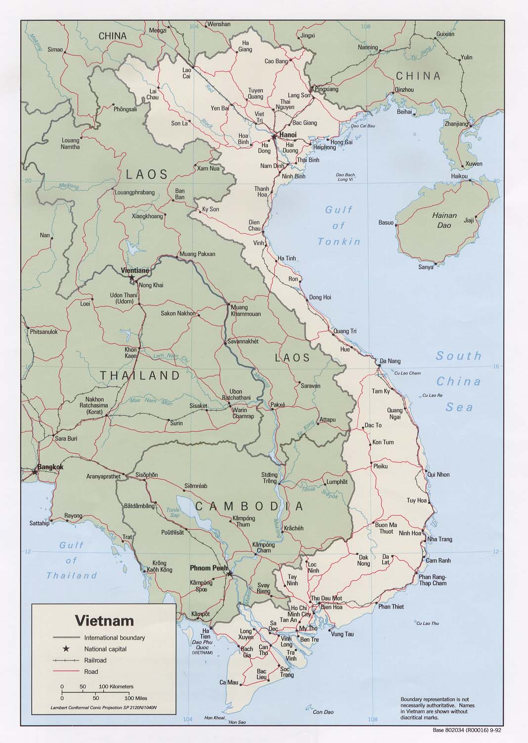
- Vietnam (Political) 1992 (189K)and pdf format (202K)
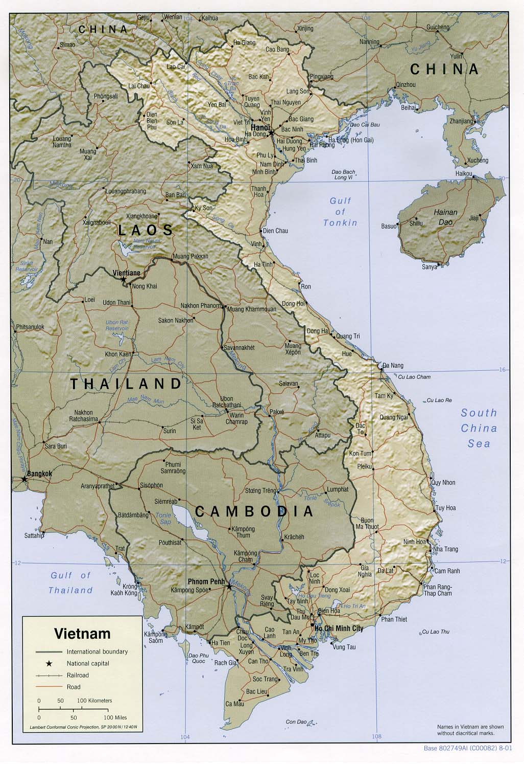
- Vietnam (Shaded Relief) 2001 (258K) and pdf format (261K)
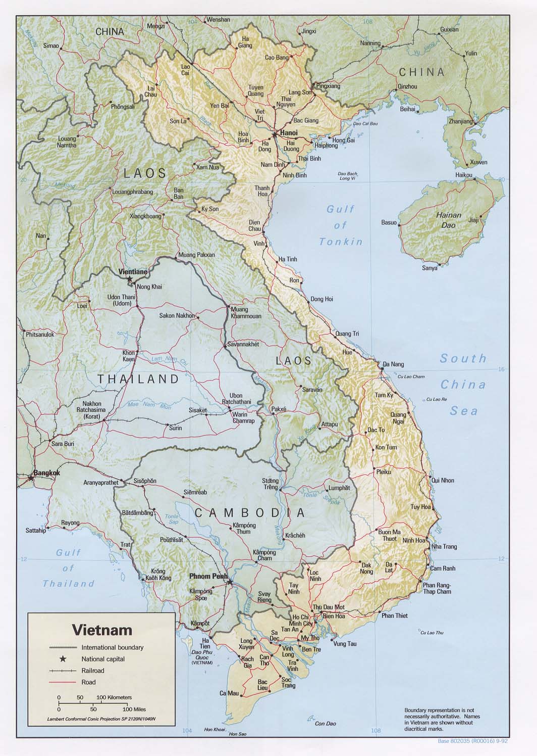
- Vietnam (Shaded Relief) 1992 (233K) nd pdf format (241K)
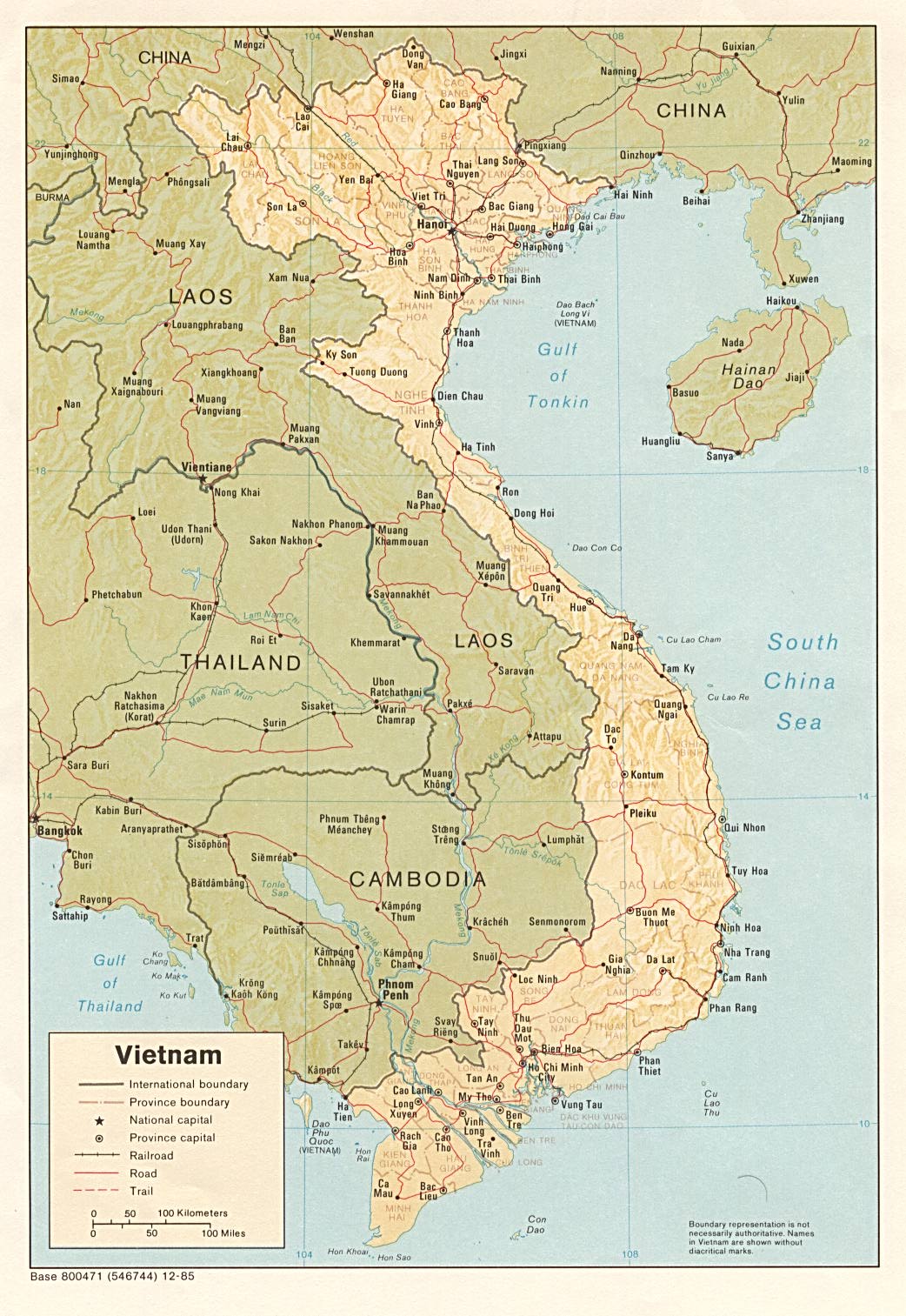
- Vietnam (Shaded Relief) 1985 (296K) pdf format (299K)
- Vietnam (Small Map) 2012 (21K)
- Vietnam: Administrative Divisions 2001 (187K) nd pdf format (194K)
- Vietnam: Administrative Divisions 1992 (139K)nd pdf format (142K)
- Bien Hoa 1:12,500, Edition 2-TPC, Series L909, National Imagery and Mapping Agency, 1968 (11MB)
- Can Tho 1:12,500, Edition 1-TPC (29 ETB), Series L909, National Imagery and Mapping Agency, 1970 (15MB)
- Chu Lai and Vicinity 1:12,500, Edition 2-TPC, Series L909, National Imagery and Mapping Agency, 1968 (18MB)
- Da Lat [Dalat] 1:12,500, Edition 1-AMS, Series L909, U.S. Army Map Service, 1963 (12MB)
- Da Nang [Tourane] 1:12,500, Edition 3-TPC (29 ETB), Series L909, National Imagery and Mapping Agency, 1969 (12MB)
- Dong Hoi 1:12,500, Edition 1, Series L909, National Imagery and Mapping Agency, 1968 (5.6MB)
- Ha Noi [Hanoi] 1:12,500, Edition 3, Series L909, National Imagery and Mapping Agency, 1968 (16MB)
- Hai Phong 1:15,000, Edition 1, Series L909, National Imagery and Mapping Agency, 1968 (15MB)
- Hon Gay 1:12,500, Edition 1, Series L909, National Imagery and Mapping Agency, 1968 (6.8MB)
- Hue 1:12,500, Edition 3-AMS (29 ETB), Series L909, National Imagery and Mapping Agency, 1968 (12MB)
- Lac Giao [Ban Me Thuot] 1:12,500, Edition 2-TPC, Series L909, National Imagery and Mapping Agency, 196- (12MB)
- My Tho 1:12,500, Edition 2-DMATC, Series L909, Defense Mapping Agency, 1971 (11MB)
- Nha Trang 1:12,500, Edition 3, Series L909, National Imagery and Mapping Agency, 1968 (6.4MB)
- Nha Trang [verso] Edition 3, Series L909, National Imagery and Mapping Agency, 1968 (2.7MB)
- Phu Lang Thuong 1:12,500, Edition 1, Series L909, National Imagery and Mapping Agency, 1968 (3.9MB)
- Quang Ngai 1:12,500, Edition 1-TPC, Series L909, National Imagery and Mapping Agency, 1966 (6.3MB)
- Qui Nhon 1:10,000, Edition 5 (USARV), Series L909, 569th Eng Co (Topo) Corps, 196- (6.2MB)
- Qui Nhon [verso] Edition 5 (USARV), Series L909, 569th Eng Co (Topo) Corps, 196- (2.4MB)
- Saigon, Sheet 1 1:10,000, Edition 2-AMS, Series L9012, U.S. Army Map Service, 1961 (8.5MB)
- Saigon, Sheet 2 1:10,000, Edition 2-AMS, Series L9012, U.S. Army Map Service, 1961 (9.6MB)
- Tuy Hoa 1:12,500, Edition 1-TPC, Series L909, National Imagery and Mapping Agency, 1968 (10MB)
- Vinh and Ben Thuy 1:12,500, Edition 3-TPC, Series L909, National Imagery and Mapping Agency, 1970 (5MB)
- Vinh Long 1:10,000, Edition 1-TPC, Series L909, National Imagery and Mapping Agency, 1966 (9.8MB)
![Da Lat [Dalat]](http://www.lib.utexas.edu/maps/world_cities/txu-pclmaps-da_lat-1963.jpg)
![Da Nang [Tourane]](http://www.lib.utexas.edu/maps/world_cities/txu-pclmaps-da_nang-1969.jpg)
![Ha Noi [Hanoi]](http://www.lib.utexas.edu/maps/world_cities/txu-oclc-232337961-hanoi-1968.jpg)
![Lac Giao [Ban Me Thuot]](http://www.lib.utexas.edu/maps/world_cities/txu-pclmaps-lac_giao-196_.jpg)
![Nha Trang [verso]](http://www.lib.utexas.edu/maps/world_cities/txu-pclmaps-nha_trang-1968-a.jpg)
![Qui Nhon [verso]](http://www.lib.utexas.edu/maps/world_cities/txu-pclmaps-qui_nhon-196_-a.jpg)
- 1:1,000,000 - Operational Navigation Chart Series U.S. Defense Mapping Agency Aerospace Center. Not for navigational use
- Sheets J-11 and K-10 cover all of Vietnam
- 1:250,000 - Vietnam - Joint Operations Graphic Series (Aeronautical Charts) U.S. Defense Mapping Agency, 1966-1998. [GeoPDF] Not for navigational use
- This series covers all of southern Vietnam and most of northern Vietnam
- 1:250,000 - Indochina and Thailand, Series L509 (Topographic Maps) U.S. Army Map Service, 1954-
- This series covers all of Vietnam
- 1:50,000 - Vietnam, Series L7014 (Topographic Maps) U.S. Army Map Service, 1964-1971. [GeoPDF]
- This series covers most of northwest Vietnam
- Sheets J-11 and K-10 cover all of Vietnam
- Indochina (Shaded Relief) 1985 (342K)
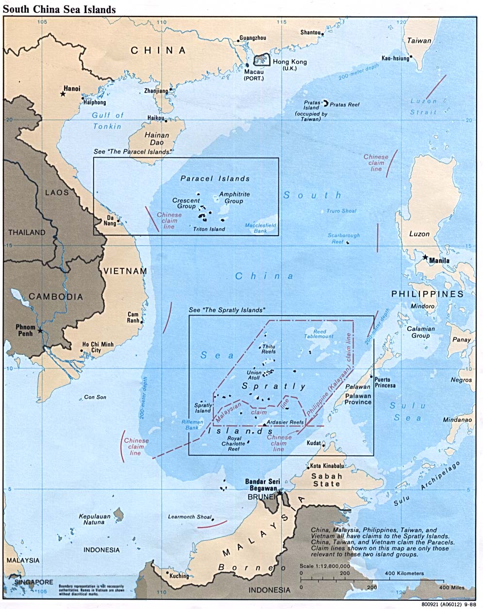
- South China Sea (Islands) 1988 (229K)
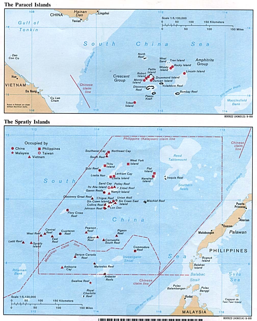
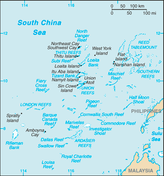
- Spratly and Paracel Islands 1988 (229K)
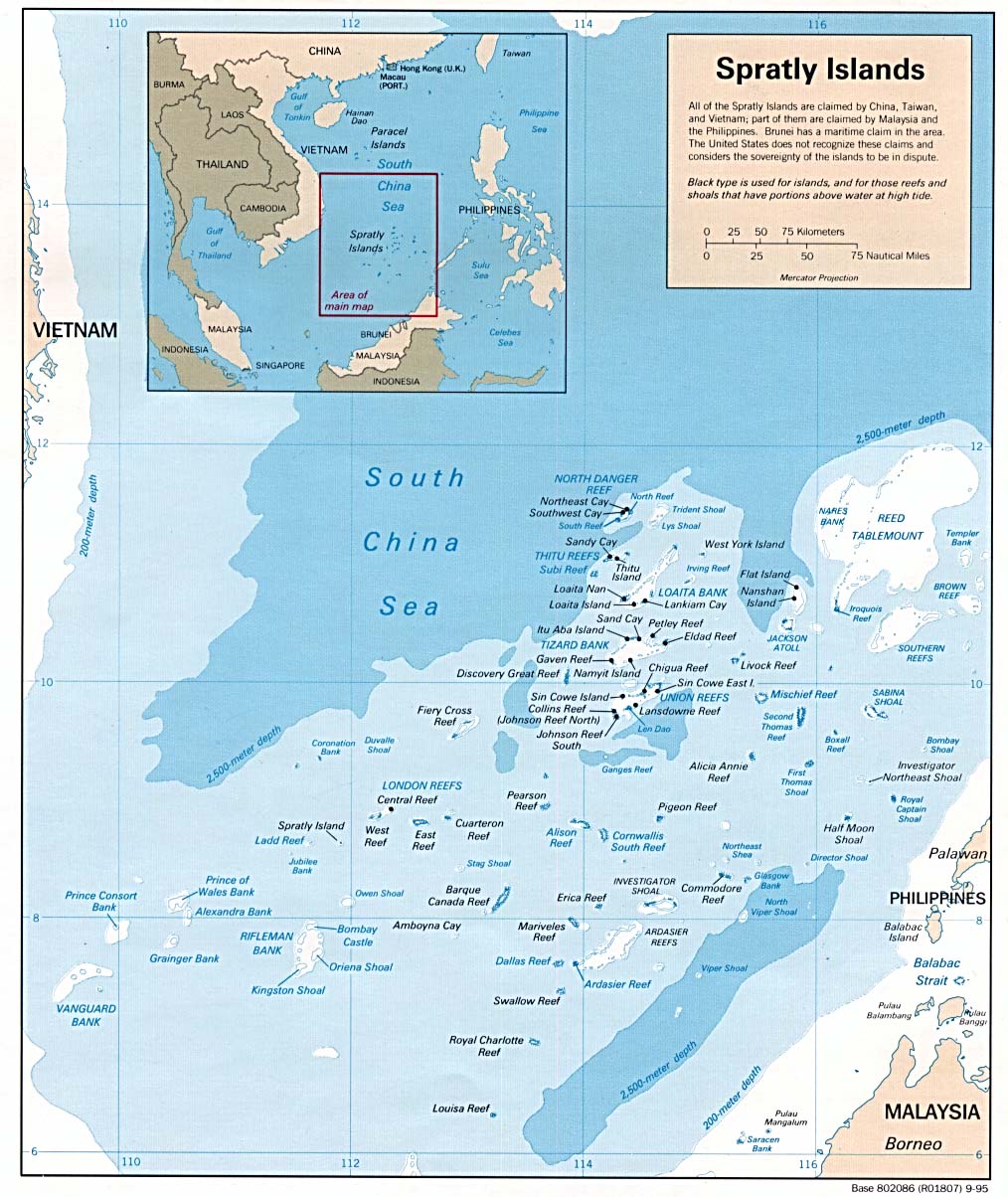
- Spratly Islands 1995 (218K)
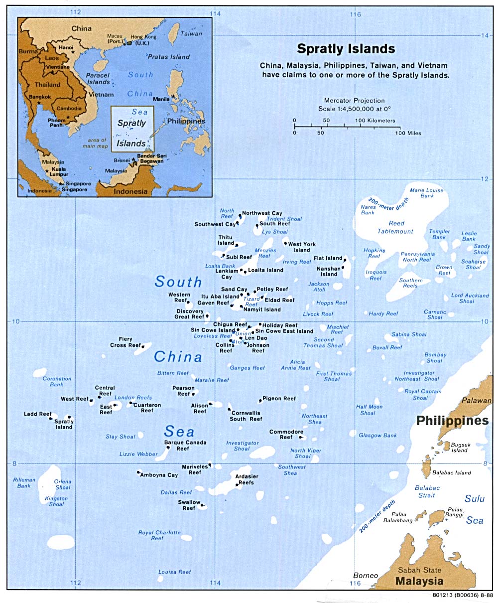
- Spratly Islands 1988 (223K)
- Spratly Islands (Small Map) 2011 (9K)
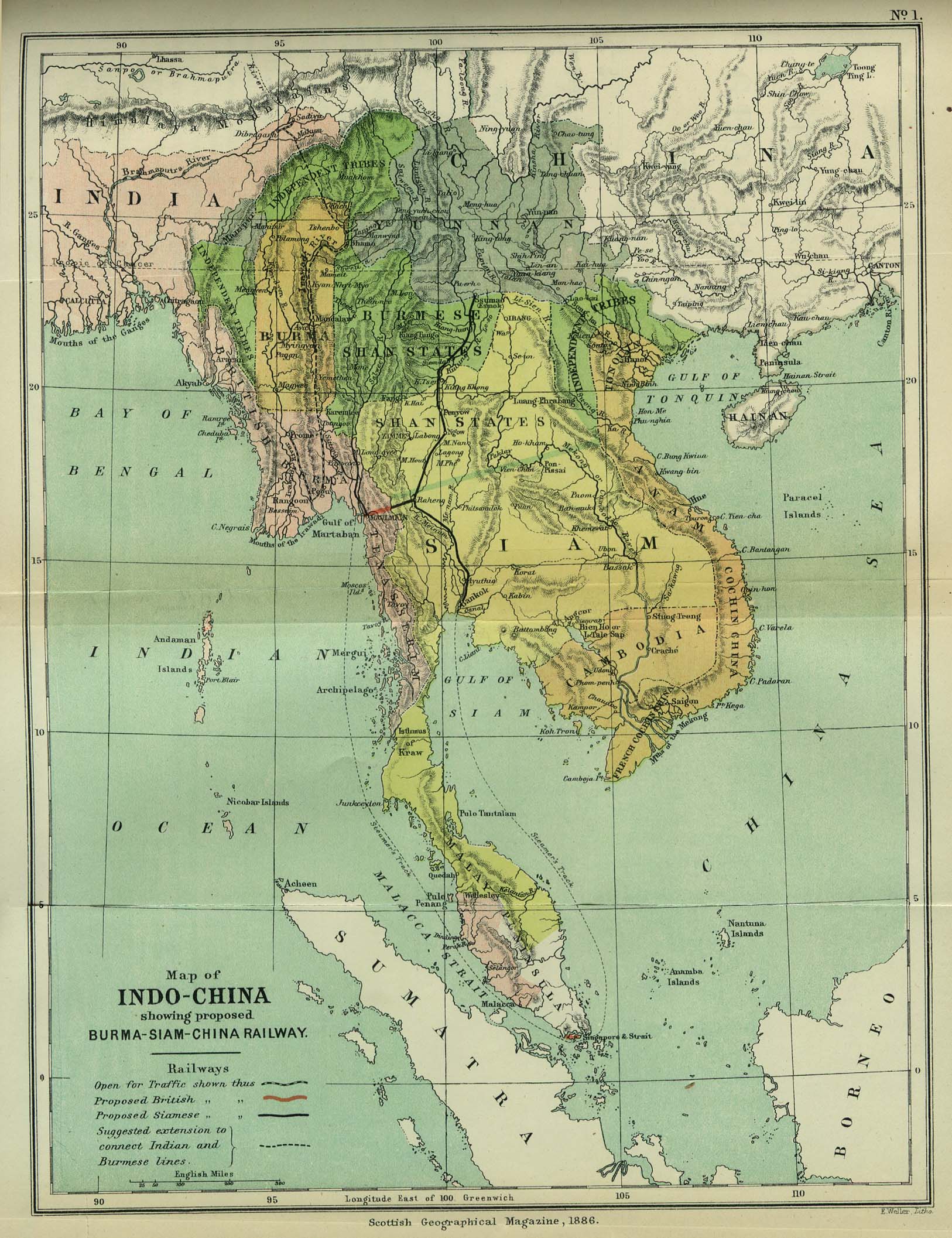
- Indo-China 1886 "Map of Indo-China showing proposed Burma-Siam-China Railway" from the Scottish Geographical Magazine. Published by the Scottish Geographical Society and edited by Hugh A. Webster and Arthur Silva White. Volume II, 1886. (533K)
- Indochina and Thailand, Series L50 (Topographic Maps) 1:250,000, U.S. Army Map Service, 1954-
- Indochina Atlas 1970
- Indochina Atlas 1970
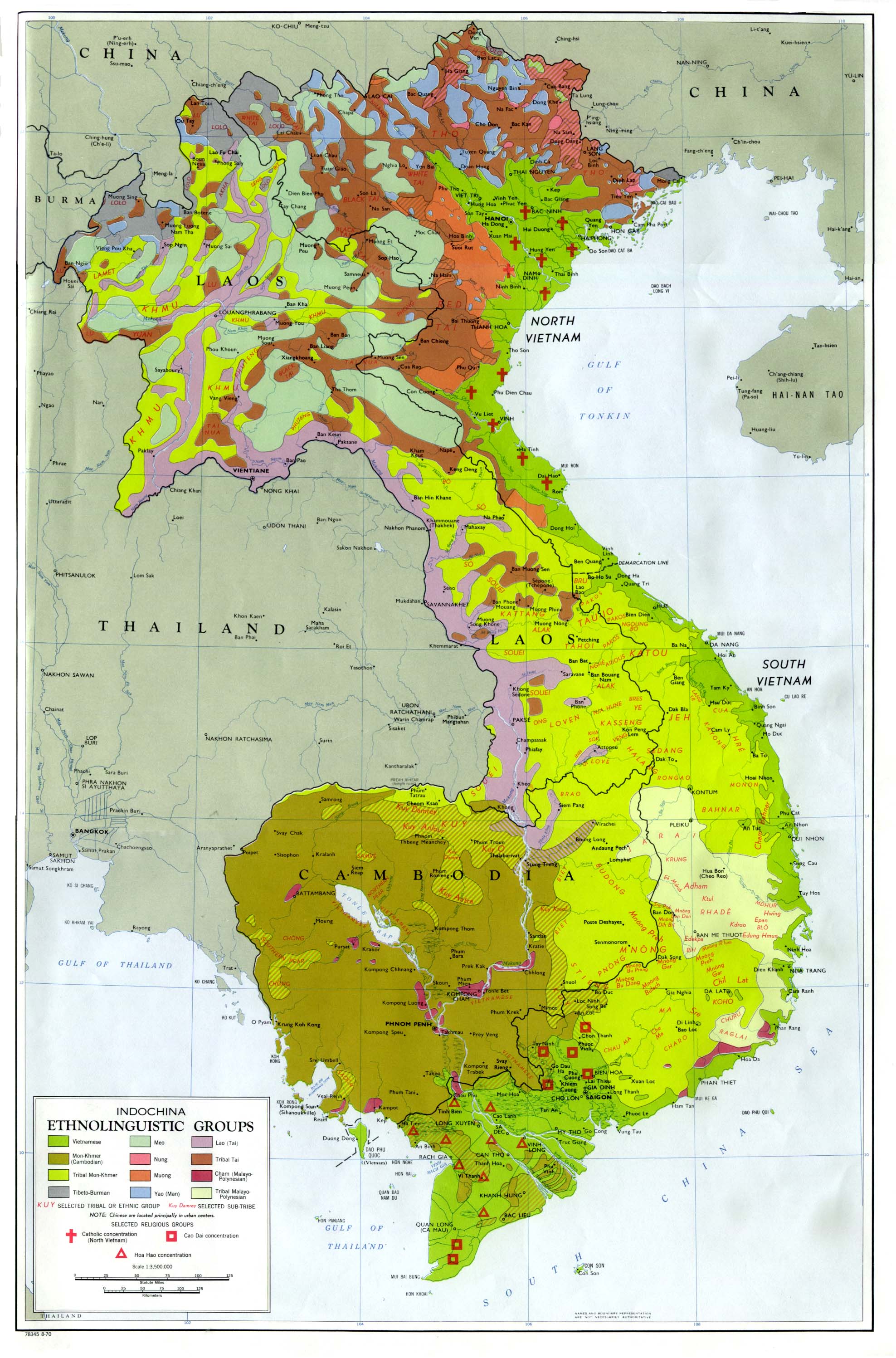
- Indochina Ethnolinguistic Groups From Indochina Atlas, 1970 (654K)
- Vietnam [South] - Economic Activity from Map No. 500874 1972 (140K)
- Vietnam [South] - Ethnic Groups from Map No. 500874 1972 (174K)
- Vietnam [South] - Land Utilization and Vegetation from Map No. 500874 1972 (174K)
- Vietnam [South] - Population from Map No. 500874 1972 (146K)
![Vietnam [South] - Economic Activity](http://www.lib.utexas.edu/maps/middle_east_and_asia/south_vietnam_econ_1972.jpg)
![Vietnam [South] - Ethnic Groups](http://www.lib.utexas.edu/maps/middle_east_and_asia/south_vietnam_ethnic_1972.jpg)
![Vietnam [South] - Land Utilization and Vegetation](http://www.lib.utexas.edu/maps/middle_east_and_asia/south_vietnam_land_1972.jpg)
![Vietnam [South] - Population](http://www.lib.utexas.edu/maps/middle_east_and_asia/south_vietnam_pop_1972.jpg)
 http://lib.utexas.edu/maps/ams/indochina_and_thailand/index_map.html
Không có nhận xét nào:
Đăng nhận xét
Lưu ý: Chỉ thành viên của blog này mới được đăng nhận xét.